Celestial navigation, once the core of global sea voyages, continues to hold critical relevance today. While GPS and satellite technology dominate modern maritime navigation, celestial navigation methods still serve as an essential skill for competent seafarers.
In a world increasingly dependent on electronic systems, understanding the principles of celestial navigation methods not only enhances accuracy but also ensures safety in emergencies. Especially when electronics fail or signals are disrupted, the sky becomes a mariner’s ultimate guide at Skillsstation, we ensure every aspiring officer is grounded in both modern and traditional navigation knowledge.
What Are Celestial Navigation Methods?
Celestial navigation methods involve determining one’s position on Earth by observing celestial bodies such as the sun, moon, planets, and stars. These methods predate modern technology and were used by explorers, traders, and military fleets for centuries.
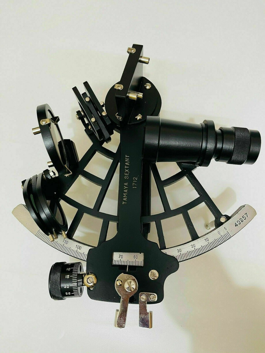
At its core, the technique requires the use of a sextant to measure the altitude of celestial objects above the horizon, a chronometer for precise time, and nautical almanacs for celestial data. The most common celestial navigation methods include:
Sun Sights (using the sun’s position to determine latitude and longitude)
Star Sights (observing fixed stars at twilight)
Noon Sight (determining latitude at local noon)
Moon and Planet Sights (used when stars or sun are obscured)
Each of these celestial navigation methods allows mariners to cross-check their GPS coordinates, maintain safe passage, and prepare for equipment failure scenarios.
Tools Required for Celestial Navigation Methods
Anyone mastering celestial navigation methods must be familiar with a few essential tools:
Sextant – The heart of all celestial calculations
Chronometer – For accurate Universal Time (UT) reading
Nautical Almanac – Provides data on celestial body positions
Sight Reduction Tables (HO 229/HO 249) – Used to convert sextant readings into navigational coordinates
Plotting Sheets and Parallel Rulers – For visual representation and plotting of positions
Modern seafarers trained in celestial navigation methods learn how to integrate these manual techniques with digital navigation tools for cross-verification.
Advantages of Celestial Navigation Methods
Despite the technological revolution, celestial navigation methods continue to be respected for their reliability and independence. Here’s why they still matter:
Fail-safe Navigation: In case of GPS failure due to system outage or jamming
Skill-based Confidence: Empowers mariners to make decisions without reliance on electronics
Regulatory Compliance: Still a part of STCW requirements and oral examinations
Deep Understanding: Offers insight into Earth’s motion, time zones, and celestial cycles
Through celestial navigation methods, officers gain not only direction but also confidence and credibility.
Step-by-Step Guide: Using Celestial Navigation Methods
Let’s walk through the basic process of applying celestial navigation methods at sea:
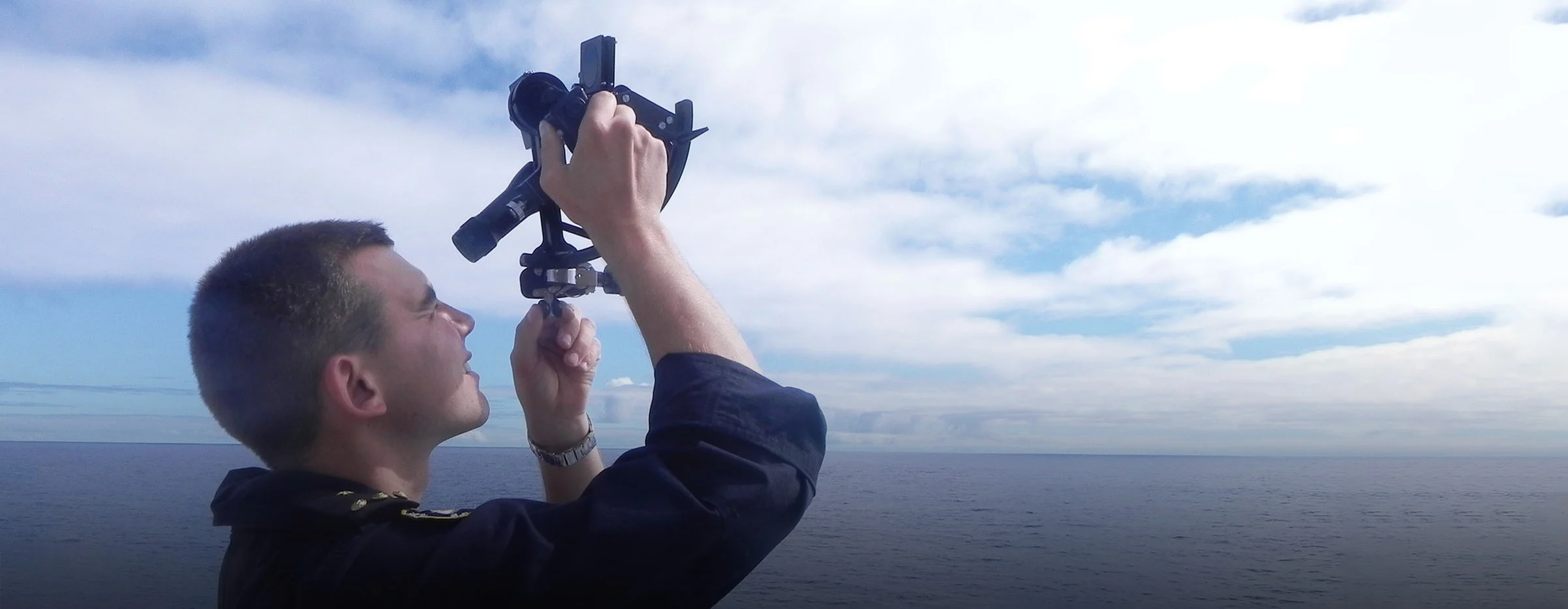
1. Measure Altitude Using a Sextant
Adjust the sextant to bring the celestial object down to the horizon. Record the observed altitude and exact time.
2. Correct for Errors
Apply corrections for index error, dip (height of eye), and refraction. This yields the true altitude.
3. Use the Nautical Almanac
Look up the GHA (Greenwich Hour Angle) and Declination for the celestial body at the observed time.
4. Reduce the Sight
Use HO 229/HO 249 tables to calculate intercepts and azimuths.
5. Plot the Line of Position
On a plotting sheet, draw the LOP. Repeat with a second celestial object or at a different time for a fix.
This structured process forms the basis of all celestial navigation methods practiced onboard.
Common Errors in Celestial Navigation Methods
Even experienced officers can make errors while applying celestial navigation methods. These often include:
Misreading the sextant
Recording incorrect time
Miscalculating correction factors
Confusing azimuth directions
Incorrect plotting on charts
At Skillsstation, such challenges are overcome through repeated drills and practice sessions, ensuring future officers are sharp and accurate in execution.
Blending Celestial Navigation with Modern Navigation
In modern-day merchant vessels, celestial and electronic navigation methods are used together. Many officers use thismethods as a cross-check for electronic fixes. This hybrid model is particularly useful during:
Long ocean crossings with minimal terrestrial references
High-latitude routes where GPS accuracy drops
Radar or AIS blackouts during cyber incidents or equipment failure
Skillsstation trains its cadets to remain comfortable with both navigation styles, making them flexible and efficient in any maritime environment.

Celestial Navigation in Exams and Maritime Careers
Many shipping companies and oral examiners still test cadets on this method It’s common in officer competency exams such as:
Second Mate COC (Certificate of Competency)
Chief Mate exams
Master Mariner assessments
Cadets who are confident in celestial navigation methods stand out during interviews and command respect among peers
Conclusion
In an era of automation and satellite-based technology, celestial navigation methods remind us that true seamanship is rooted in knowledge, observation, and skill. These age-old techniques are more than backup plans—they are symbols of a seafarer’s competence and resilience. At Skillsstation, the Best merchant navy coaching institute Skillsstation, cadets receive intensive training in both modern and traditional practices. With a strong foundation in celestial navigation methods, Skillsstation prepares future officers for every challenge—sky or sea.
 Chat with us